 traces of prehistoric or even historic
use of an area. Therefore, survey is one of the first steps one takes to
physically look for things such as artifacts.
traces of prehistoric or even historic
use of an area. Therefore, survey is one of the first steps one takes to
physically look for things such as artifacts.So how do archaeologists know where to look for artifacts, features, and archaeological sites? The answer is really quite simple. They can rely on past knowledge. Sometimes one knows where sites use to be from earlier exploration. For example, we know that people looking for archaeological materials back around 1920 observed artifacts and other things scattered in what is now part of Phoenix. So in some cases, we already know where things are - or were at least.
In other cases, archaeologists must first look at the
surface of an area through what is called an archaeological survey. They
look for any traces of prehistoric or even historic
use of an area. Therefore, survey is one of the first steps one takes to
physically look for things such as artifacts.
Once an archaeologist knows that there are traces on the surface or that something use to exist at a particular location, they will begin to excavate. Excavation involves the disturbance of the archaeological record to some degree. It involves digging into the ground with the intent of recording what is found. Let me walk you through the early stages of one excavation.
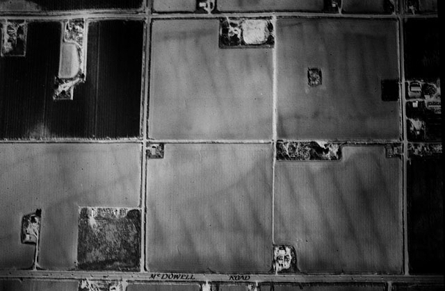
Artifacts had been observed on the surface of the ground
during a survey. Prior to the survey, archaeologists had checked older records
and discovered that an archaeological site had been observed in this area
(view an aerial photograph showing prehistoric
canals.)  Subsequently,
the area had been used as a farm and had been plowed. The first goal of
the excavation was to discover it the site still remains or had been destroyed
by the plowing. A backhoe was used to excavate a series of trenches. Archaeologists
then looked in the walls of these trenches to see if there were features.
The trenches were a preliminary way to pierce the surface and look below
it to see if there was anything present. And - there was.
Subsequently,
the area had been used as a farm and had been plowed. The first goal of
the excavation was to discover it the site still remains or had been destroyed
by the plowing. A backhoe was used to excavate a series of trenches. Archaeologists
then looked in the walls of these trenches to see if there were features.
The trenches were a preliminary way to pierce the surface and look below
it to see if there was anything present. And - there was.
 Archaeolists
discovered that just below the dark soil created by the farming activities
that had occurred for nearly 40 years that prehistoric materials survived.
Look closely at the picture to the right and you will see the dark soil
at the top and a white line just below it. That white line is the floor
of a prehistoric house.
Archaeolists
discovered that just below the dark soil created by the farming activities
that had occurred for nearly 40 years that prehistoric materials survived.
Look closely at the picture to the right and you will see the dark soil
at the top and a white line just below it. That white line is the floor
of a prehistoric house.
The next phase of the excavation was to clear the area
around that house and excavate the house itself. At this point, the archaeologists
worked more carefully and used shovels and trowels eventually to  locate the floor
and any artifacts or other features that might be associated with it. The
picture to the right is that house after it was excavated. Archaeologists
recovered a number of artifacts from this house. Some of these could be
used to provide a relative date to the house. It belongs, based on similarity
in designs on pieces of pottery found on the floor, to a time period that
existed about 800 to 900 years ago.
locate the floor
and any artifacts or other features that might be associated with it. The
picture to the right is that house after it was excavated. Archaeologists
recovered a number of artifacts from this house. Some of these could be
used to provide a relative date to the house. It belongs, based on similarity
in designs on pieces of pottery found on the floor, to a time period that
existed about 800 to 900 years ago.
The archaeologists also found a clay fire hearth in
the wall of the trench. This hearth is important because it can be dated
using a technique of dating known as archaeomagnetic dating. This involves measuring the polarity
of magnetism that was created when the clay was last hot (fired). At that
time, the magnetic particles aligned to what was magnetic north at that
time. Magnetic north has shifted over time and we know the pathway of that
shift. By comparing the magnetic pull from the hearth, archaeologists can
derive a fairly accurate date for when that hearth was last use - inferring
when the house was last used.
measuring the polarity
of magnetism that was created when the clay was last hot (fired). At that
time, the magnetic particles aligned to what was magnetic north at that
time. Magnetic north has shifted over time and we know the pathway of that
shift. By comparing the magnetic pull from the hearth, archaeologists can
derive a fairly accurate date for when that hearth was last use - inferring
when the house was last used.
In essence, an archaeological excavation proceeds from
what the archaeologist can observe and testing outward to what is around
that reference point. Just as with the use of the backhoe trench to first
probe what is below the ground, the archaeologist excavates outward to discover
more information by probing into areas.