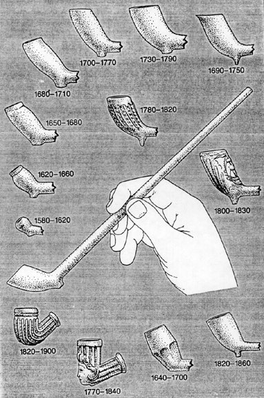
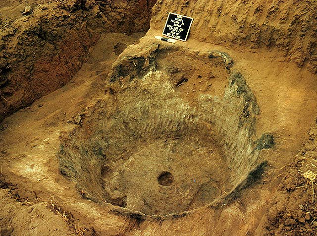
We also know that styles of things tend to change. All we have to do is look at automobiles from the 1950s, 1960s, and/or 1970s and compare them with those around us today. The styles have changed for a variety of reasons. Archaeologists use this to help them reconstruct time. This is something known as seriation. It has long been a fundamental way to tell time in the past. If you click this, you will see how pipes changed over time. By researching historic records, archaeologists know when particular pipes were made. If we find a pipe that looks like those made around 1580 to 1620 in our excavated site, we know that the site was occupied around that time. If we find other types of pipes, we can determine how long the site may have been occupied. We have been able to date the site. Archaeologists also rely on a variety of different techniques such as radiocarbon or archaeomagnetic dating to derive dates for the past.
Brian Fagan and George Michaels have put together a wonder look at how archaeologist use dating techniques literally to tell time. If you wish, you can explore this link:
Even if we can't tell time very well, we can look at the archaeological record and begin to put things together simply by knowing something about the context of the artifacts and features left for us.
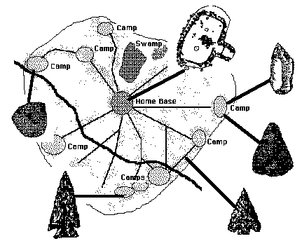
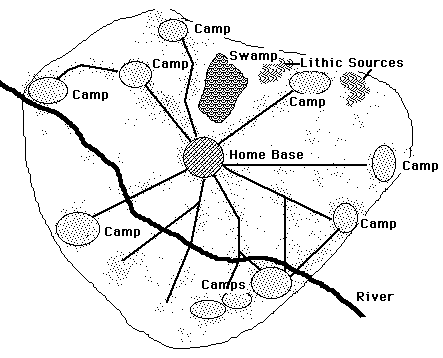
Certain areas can be identified as archaeological sites. Archaeological sites can be classified into types. Generally these will reflect activities that can be inferred from the types of artifacts and/or features present at a site. It can be said that attributes of each site can be used to type sites. A house feature, for example, will tell us that people lived in a particular spot. This we can think of as a homebase or habitation site. We would expect a wide range of different artifact types to be found at sites such as this. In contrast, camps or limited activity sites will have less diversity of artifact types and the behavior that created these sites will be directed at specific task such as the killing and/or butchering of an animal.
Archaeologists use inference to build the archaeological reconstruction. For example, the pattern of artifacts spread across this landscape suggests that there was a system of trails that once was used to connect different activity areas. The inhabitants of this region discarded, for whatever reason, artifacts along these routes of connection. We can trace those routes through the artifact distribution. We infer that this represents the paths that people took to get from one place to another.
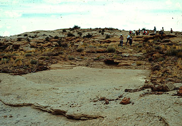
The following picture shows a portion of a prehistoric road from Chaco Canyon in New Mexico. Archaeologists have used aerial photography to trace more than 500 miles of roads leading out from Chaco Canyon in different directions. We can look at the width of these roads and we can trace there directions. Those are observations. What archaeologists infer is the use of these roads. We don't have the people around to see exactly how these used the roads but we do observe the roads themselves. It is important to differentiate between what you can observe and what you must infer.
Activities usually can be inferred based on what we observe. We can never be totally certain that our inferences are correct. What archaeologists do, however, it make certain that the observations they make can lead them to inferences that are supported by those observations. That is why archaeologists carefully record things like context and attributes as they build the based by which they can infer behaviors.
Archaeologists use all sorts of different kinds of information to build their base of observation. For example, knowledge of the environment may help to place the archaeological remains into a context by which archaeologists can reconstruction the types of behaviors associated with a group of people who used an area such as the one near the Santan Mountains.
Let me show you how this works
in the following example. Archaeologists surveyed an area north of Phoenix. They found a series of rock alignments and piles. They observed
a particular type of agave plant growing in several spots.
Phoenix. They found a series of rock alignments and piles. They observed
a particular type of agave plant growing in several spots.
They also found a number of artifacts that are called "primary flake tools" They are large in size and were made by hitting one rock upon another to remove a large flake that could be used to cut.
 What
we know (through observation) is that this type of agave does not grow
naturally in this region of Arizona. We also know that it reproduces in
a certain way. The plant first sends out a tall stalk that has blooms at
the end. These are fertilized by bats and insects. Instead of growing seeds,
this plant actually
What
we know (through observation) is that this type of agave does not grow
naturally in this region of Arizona. We also know that it reproduces in
a certain way. The plant first sends out a tall stalk that has blooms at
the end. These are fertilized by bats and insects. Instead of growing seeds,
this plant actually  produced
small plants at the end of that stalk. The stalk eventually deteriorates
and the plants land on the soil to hopefully grow roots and mature.
produced
small plants at the end of that stalk. The stalk eventually deteriorates
and the plants land on the soil to hopefully grow roots and mature.
What happens in regions such
as this one is that it is hotter than where the plant naturally grows.
Therefore, the plant does not reproduce effectively in this environment.
Instead, it relies on a backup system of reproduction sending out  roots
that spread new plants. This is a less than effective backup but it has
left a few plants for the archaeologists to find.
roots
that spread new plants. This is a less than effective backup but it has
left a few plants for the archaeologists to find.
What else we know is that agave, particularly this type of agave, has many uses. It can be roasted in an oven and cooked. It is high in nutrient values. We know that living people who use agave have used it for other purposes included for medicine and even clothing. So it is a versatile plant with many uses. We also know that in other areas, the prehistoric people of southern Arizona grew this plant in large fields where they constructed rock alignments and rock piles. Through experiments, we have discovered that the moisture around the base of the rock piles increases thereby providing a little extra moisture to plants that are growing at the base of these piles. The rock alignments tend to trap water as it runs across the ground thereby also enhancing a region so that plants can capture more of the ground moisture. In a hot, dry desert environment, rock alignments and rock piles are an ingenious way to enhance growth of plants such as agave.
So what can we infer about all of this? Well, we can infer that people brought this plant into this region from where it naturally grew. That they probably had to help the plant reproduce. Since the plant puts off more than 50 little plants per stalk, this means they could use a great number of agave plants for food and other things and keep a ready supply of plants growing. They simply had to break the stalk and plant the new "seedlings" in the right areas - such as at the base of pile of rocks. We can, therefore, infer that the agave growing in this area was part of an elaborate agricultural system operating prehistorically.
